
Visibility from Summit Increasing Over Time
By Brian Fitzgerald, Director of Science & Education | June 15, 2021

Weather Observer Sam Robinson stands above the clouds in December 2020. Observers record prevailing visibility at each of their 24 hourly observations, every day of the year.
Visibility appears to be generally increasing over time on the summit of Mount Washington since our continuous record of visibility began in 1943.
This noteworthy finding comes in the wake of an initial data exploration and analysis of Mount Washington Observatory’s (MWO) long-term visibility records, completed by Weather Observers Jay Broccolo and Sam Robinson in Spring 2021.
The project report, entitled “A Data Exploration of Visibility at Mount Washington Observatory (1943-2020), KWMN: Key Findings” was recently published to help the public understand the background, motivation, relevance, findings and suggestions for further study.
The exploration grew out of public and staff interest initially related to the COVID-19 pandemic and its effect on the environment. Back in spring 2020, our staff fielded a number of inquiries asking if the weather observers were able to see farther than usual due to the global reductions in industry, transportation and overall aerosol emissions. It was a tricky question to answer, because in order to respond with any confidence, one would have to know what “usual” visibility is, and would certainly require a lot of visibility data over time to compare against.
For those wondering how visibility is measured in the first place, understand that MWO’s weather observers record something known as “prevailing visibility” at every single hourly observation, both day and night, by determining which known landmarks and distances that they can see on the horizon.
As the highest point in the Northeast with a treeless summit, Mount Washington’s position allows for an unobstructed view in all directions (provided you’re not in a cloud). The naked-eye view from the summit can reach up to 130 miles to Mt. Marcy in NY, for example, 79 miles to Camel’s Hump in VT, or 67 miles to the Atlantic Ocean off the Maine coast.
At night, observers use many of the same natural features plus the lights of known locations to assess the visibility. For context, most weather stations that report visibility are at airports with automated instrumentation to help pilots and traffic controllers assess take-off and landing conditions. Visibility at these stations will only report up to 10 miles as the highest value of interest.

A map of concentric circles around the summit with visibility markers indicated. The inner-most circle is 20 miles, while the outer-most circle is 130 miles away.
For nearly a year, Broccolo and Robinson dug into paper and digital visibility data, gathering any related information including measurement standards and observer training materials.
Two pieces of critical information were discovered early on: 1) 24-hourly visibility observations began continuously in 1943, with reporting being more intermittent previously, and 2) prevailing visibility records before 2008 exist only on paper, and digitally from 2008 to present.
Without taking on the hugely exhaustive process of manually entering data from paper forms into a digital database, Broccolo and Robinson were able to use a nearly identical visibility variable: lowest prevailing visibility. This value had been digitized along with all values on the daily B-16 Form during a recent project by observers and interns.
Lowest prevailing visibility is what it sounds like. It essentially means the lowest prevailing visibility reported in the last two observations. So if two hours ago the visibility was reported at 1/16 of a mile, and this current hour the visibility improved to 50 miles, the lowest prevailing visibility for this hour would be 1/16 of a mile. Through a direct comparison of lowest visibility versus prevailing visibility from 2008 to present, it was found that both of these variables tracked very closely, making lowest visibility an acceptable proxy.
With data in hand, Broccolo and Robinson examined seasonal and annual average lowest prevailing visibility to explore what long-term trends or anomalies may have been present. The initial analysis appears to show a steady increase in visibility first appearing in the 1950s and then increasing at a higher rate starting in the early 2000s. Public interest in whether average visibility was found to be increasing due to the COVID-19 pandemic in 2020 was not easily discernible.
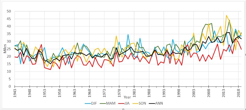
Seasonal averages of lowest visibility (miles) at KMWN (December, 1942 through November, 2020).
In future investigations, a number of different questions may be explored, including what if any difference exists between day and nighttime visibility observations, or how these visibility data compare against other atmospheric measurements such as particular matter concentrations or wind speed and direction.
“The next steps would be to analyze the data deeper and corroborate the findings with other measurements,” Broccolo said. “Further statistical analysis is required to show the quality of data. Measurements of air quality affecting particulates at a similar geographic location and elevations or the development of a measuring system at the summit of Mt. Washington would also be of interest in order to compare visibility and air quality.”
Regardless of which investigations come next, the value of MWO’s visibility dataset is immense. No other record of similar location, length, resolution or quality truly exists, which makes it a tremendous asset for studying the relationships between visibility and air quality over time in Northern New England.
Whether examined internally or through partnership, the possibilities for future work are clear to see, so to speak. Read the full project summary report.
MOUNT WASHINGTON OBSERVATORY NAMES DREW FULTON BUSH AS NEW EXECUTIVE DIRECTOR
North Conway, NH – September 14, 2022 – Mount Washington Observatory (MWOBS), a nonprofit research and educational institution working to advance understanding of Earth's weather and climate, has appointed nonprofit leader, researcher, and educator Dr. Drew Fulton Bush as the organization’s new Executive Director, beginning Sept.
September Newsletter: An Exciting Month as We Begin a New Chapter
Support the Observatory Become a member Renew your membership Snow and ice coat the summit cone of Mount Washington in the foreground as the morning sun illuminates the northern Presidential Range on Sept. 25. Dear Keith, Earlier this month, Mount Washington Observatory began a new chapter
Septem-burrr!
Septem-burrr! 2022-09-25 20:07:59.000 - Ryan Knapp, Weather Observer/Staff Meteorologist The summit of Mount Washington has experienced freezing temperatures and rime/glaze ice three times (so far) this month. And with the recent cold snap, the summit also received some snow/sleet. When we posted images and videos about

Reflections on a Mount Washington Summer
Reflections on a Mount Washington Summer 2022-08-26 15:00:13.000 - Henry Moskovitz, Summit Intern Having concluded my summer internship at Mount Washington Observatory, I look back on a beautiful, exciting summer full of meaningful work,

A Marine Biologist in the Mountains
A Marine Biologist in the Mountains 2022-08-15 14:34:28.000 - Naomi Lubkin, Summit Intern Summit Intern Naomi Lubkin on the observation deck. My first shift at the Observatory was a cold, clear day back in

Understanding Weather as a Source of Empowerment and Awe
Understanding Weather as a Source of Empowerment and Awe Francis Tarasiewicz on the summit observation deck. “For thunderstorms, we either make them or break them.” “Our winds are typically strongest when they’re coming